From Snow to Tornados - March in Like a Lion
Severe Weather Threat High Today: Tornadoes, Hail, Severe T-Storms, Winds

Area/School Closures (from WTKR-3)
FYI: The Origin Story of the Proverb: In like a lion, out like a lamb.
Just a week ago there was a chance of snow, now there’s a chance of tornados. To quote Seinfeld: What’s the deal with that?
Chance of Tornados today (Monday 3/16/26): ~100%. But not 100% of people will see one, just ~100% probability that one will occur in the higher risk areas. This is impossible to predict. Someone, somewhere in eastern VA, will experience a twister, but we can only guess at probabilities and where the largest chance of experiencing one might happen. We can also estimate the timing of the worst weather and how severe it might be.
Timing: Virginia Beach: around 1:00-4:00 pm, and again between 6-8 pm after the atmosphere reloads (cools down, sun coms out, heats back up). Check out the images below. These are probabilities. It could happen anytime.
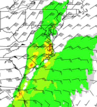
I like this overall map. It shows the potential Tornado threat (thanks Dupage College). It’s highest (red) at 18Z (1pm), 19Z (2pm), and 00Z (7pm). And highest right near us.
Here’s 2:30-4:30 pm. VB is right in the warpath.
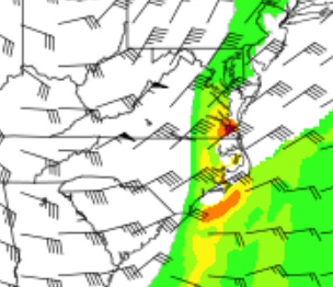
And again at 7pm as the atmosphere “reloads” & the cold front passes through.
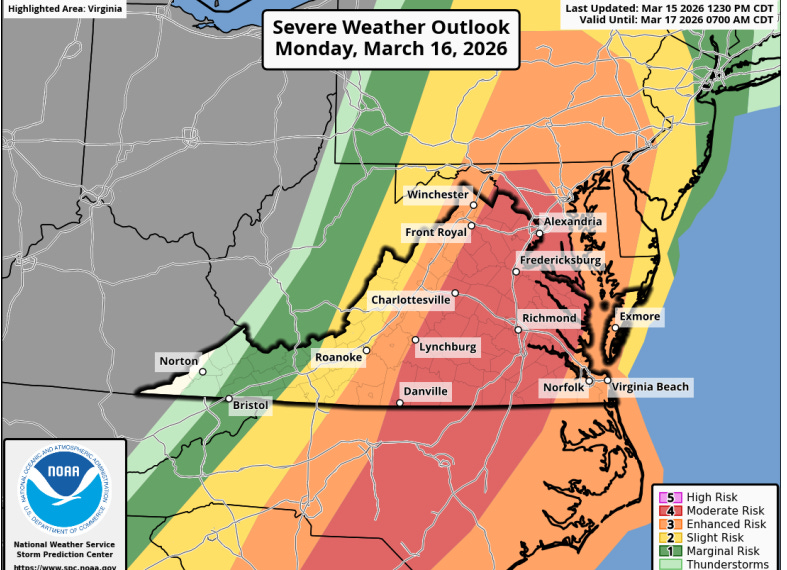
Here’s the overall threat level for Virginia from Noon today to 6AM Tuesday.
Educational Information
What do you need for a Tornado to form?
VERTICAL INSTABILITY: Hot air meeting cold air. That occurs with a cold front passage. March, April, and the corresponding fall months have the greatest extremes of temperature on either side of the front, meaning the highest chances of VERTICAL INSTABILITY (air moving up and down). Air is moving South to North in general, and this is a powerful cold front, so the air is moving very fast.
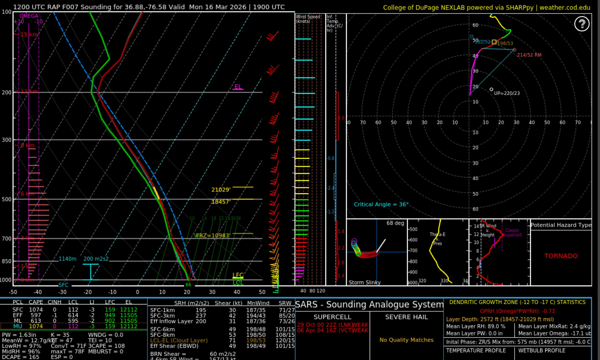
HORIZONAL INSTABILITY: You need rotation, like a miniature hurricane. Hurricanes are massive, slow, and you can seem them coming for days. Tornadoes are small, quick, and form just as quickly as they die off, making predicting them tough. That’s why probabilities are given. Today, there’s a high amount of wind shear. The first few thousand feet off the ground, the wind is turning about 36 degrees. Tornados need 30-60 degrees of spin.
ENERGY: You need wind shear (horizontal and vertical vorticity) but you also need a lot of energy. That’s why they don’t occur in winter, cold air can’t hold much energy. But warm air can. We measure it in a term called CAPE Convective Available Potential Energy. CAPE today is 1074 J/kg — let’s just say that is strong enough for tornado formation and some nasty thunderstorms. CAPE goes as high as 4000, though, just as a reference.
A LOW Cloud Deck: Tornados have to touch ground, so it helps when the ground isn’t that far from the clouds. Today it’ll be around 350 feet, like a Norfolk Skyscraper. Pretty low. Tornadoes need less than 1000 feet.


So we need WIND SHEAR (Vertical plus Horizontal Instability to get that turning motion), Energy from our cold front (CAPE), and a low cloud deck (as low as 350 ft).
For those true weather geeks, I use this diagram, called a SKEW-T diagram to help determine these parameters. Think of it like an EKG machine. At the bottom right, it even prints the diagnosis, like an EKG machine: TORNADO. This is at 19Z, 2:00 pm. Zulu time is 5 hours ahead of us, so 19Z is 1900 Zulu, 7pm Zulu, so 2:00 pm here.
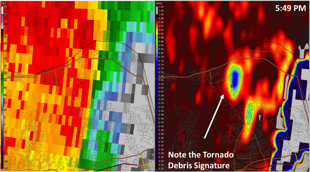
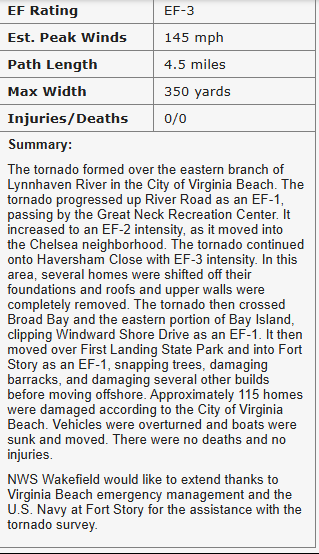
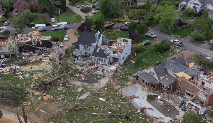
For nostalgia’s sake, a couple pics from the Haversham Close area tornado April 30, 2023. These are so hard to predict. I live 3/4 of a mile away and had no damage. Yet this entire neighborhood is still recovering. Ultimately, the damage really depends on where the population density is also. Many tornadoes occur where no one lives (Great Plains, Midwest). Just a shout out to the National Weather Service who sounded the Tornado Warning alert. Not a single loss of life. Incredible!
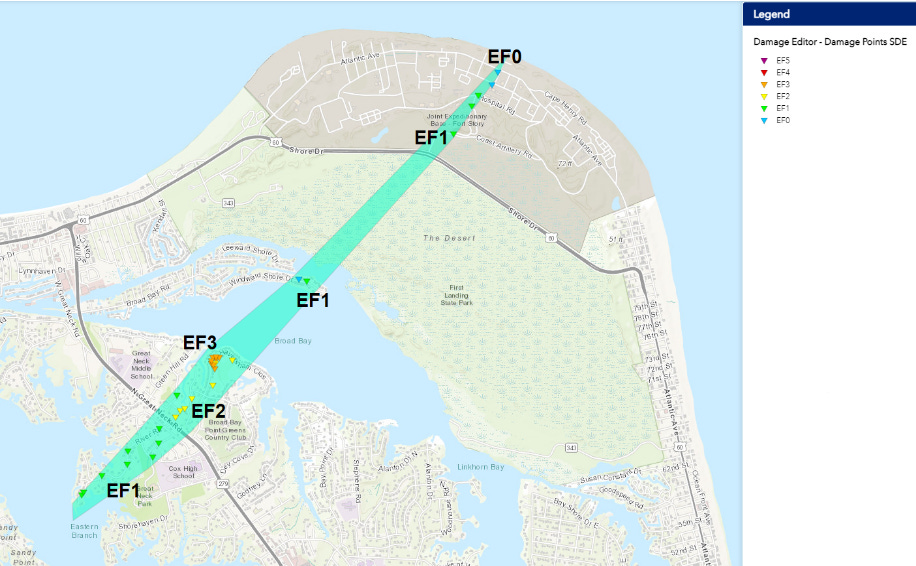
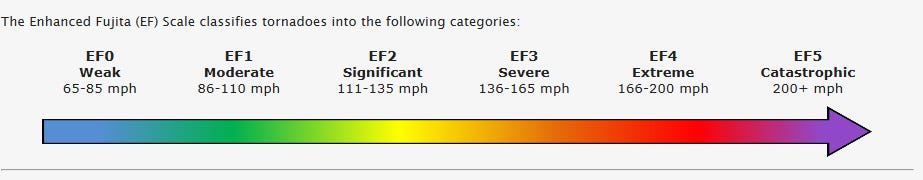
One of the coolest radar signatures of a live tornado. The one from 4/30/23. Note the areas where the red meets the blue/green. That’s the Doppler signature of a tornado. Winds moving fast coming toward and away from the radar site. The meeting of the colors indicates a tornado, at least one in the air. Max: EF3.