

Well, folks, we’re officially in wait-and-watch mode. And unfortunately, I don’t have a definitive answer for what Sunday is going to bring.
The main window of concern is still Sunday morning, approximately 3 AM to 11 AM, when we could see a squall line with gusty winds and heavy tropical rain. I’m not expecting much in the way of thunderstorms with this initial round, just those big, heavy tropical raindrops that can soak everything in a hurry. Isolated thunderstorms remain possible later in the afternoon as daytime heating interacts with the leftover tropical moisture.
After 11 AM, we’re looking at a tale of two weather models, and they have very different endings.
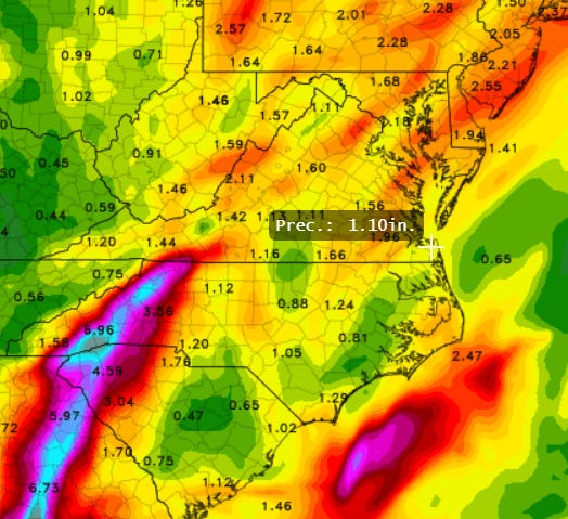
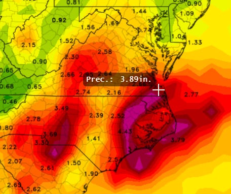
The short-term ETA model is predicting around 1 inch of rain ending by noon, while the GFS model is showing nearly 4 inches ending by Sunday at midnight! That’s a pretty significant difference, especially considering we’re talking about the same storm, the same area, and the same day.
These are two of our more reliable weather models, which makes it particularly frustrating that they can’t seem to agree.
The problem is that when hurricanes begin to fall apart, predicting where all that tropical moisture and energy will end up becomes incredibly difficult. It’s almost like the storm’s insides explode, and you never quite know who’s going to get splattered.
So What Should You Do About Your Sunday Plans?
Here’s what I’m feeling much more confident about: Saturday looks great. Monday looks great. Sunday? Still very much up in the air. You might need an umbrella Sunday. You might need a boat. Welcome to tropical weather forecasting!
My advice is simple: Don’t cancel your Sunday plans just yet, but be prepared for a nasty day.
I wouldn’t throw in the towel just yet. There’s a 50% chance most of it will be over by Sunday at Noon. There’s a 50% chance it’ll stretch well into the evening.
If you’re organizing something that requires a firm decision, I’d suggest waiting until Saturday’s forecast update before making the call, assuming you have that flexibility. Hopefully, by then, the ETA and GFS will have come to some sort of agreement.
And I’m sorry this forecast has been so difficult to pin down. I know people are trying to make weekend plans, and nobody likes a forecast that keeps changing. Unfortunately, the breakdown of a tropical system is one of the trickier things to predict, particularly when it’s moving this quickly.
The ETA model - supposedly the best short term model. 1” predicted.
The GFS. 2nd best. Almost 4” predicted.
FYI: How to Pronounce ISAIAS: CLICK HERE (ee-SAH-ee-ahs) TO HEAR
In Spanish, the name has four syllables, with the emphasis on the second syllable. It’s the Spanish form of Isaiah. I still can’t say it correctly, even after hearing it.
Best Overall Loop
Best Visible Loop
Forecasted Track
Wind Forecast
Rain Forecast
Technical “Discussion” from the National Hurricane Center about Isaias