
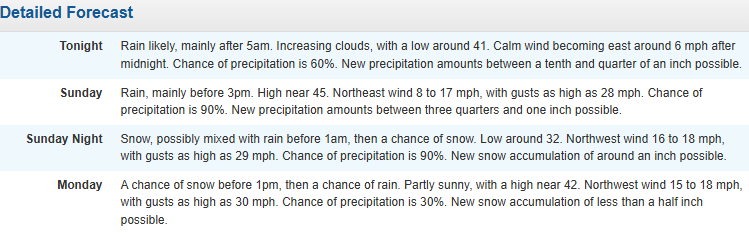
Not again! Models crush my heart. Chances of big snow shift north, maybe an inch expected here.
We might get an inch, it'll look pretty if you're up between 1-7 AM Monday morning, but once again, we missed the big one by 100 miles.

Chance of Snow: (Of seeing snow): 90%.
Snowfall prediction as of now: Up to one inch on areas that cool quickly: grass, shrubs, trees.
Chance of school getting cancelled: 30%, some places may get just a tad more, and you just never know with VB schools.
Chance of a 2-hour delay: 70%; any snow that falls will fall early Monday before daybreak, the coldest part of the night, where any sticking may take place. This may make school supervisors hesitant on which neighborhoods are affected more than others. Better to be safe than sorry in Virginia Beach. But I think the streets will be fine. Chances are school will have a shortened but normal day. Sorry kids!
When? starting early Monday AM (like 1 AM), ending by 11AM.

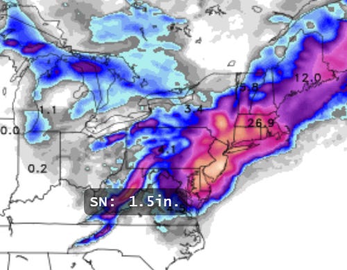
So as has happened this whole winter, Virginia Beach has been in the crosshairs of multiple potential snowstorms where the computer models suggest 1-2-3 ft of snow 4-5 days out, only to have the storm shift position by 50-100 miles by the actual event. That, though, can make all the difference in the world. In this case, there was a lack of cold air around. Normally it would have been in the 20’s and 30’s leading up to a major event like this. But it’s been in the 60’s. There no real cold air around, and the streets have been warmed over the last several days. So the only way to get snow is by what’s called “dynamically cooling” the atmosphere, where it snows so hard that it forces the cold air down from higher altitudes onto us. That is what will happen, but we will drop down from 40 to 32 or 33 degrees, and that’s just not cold enough to make the snow stick quickly. Area just a little further north will drop into the upper 20’s, cold enough to get the snow to stick. The computer models are still churning out blizzard condition for Delaware, MD, PA, NYC, Boston, Rhode Island, and suggesting 2+ feet of snow. But since this is a dynamically cooling event, a lot of that snow will be “lost” to cooling the atmosphere and bringing down the temperature, so you can cut those snow totals by 1/2. Here’s how much can be expected by the computer models, and then in reality.

This from the NAM - generally the best overall model. FYI, all models are generally in agreement. If the temperature was cold enough, up to 26.9 inches could be expected in Massachusetts. The Eastern Shore by get 6-12. The bullseye is the coast of central NJ, around 30 inches. But again, divide by 2, even 3, because of how wet the snow is, and how much snow is wasted on making the air cold enough to even snow in the first place.
If you look at VB, we’re expecting 1-2 inches. I think that’s optimistic even. If anything sticks, it’ll be on trees and grass, but the streets are just too warm. But with city public schools, you just never know.

Forecast from the Wakefield weather office (official NWS):
From the weather service (the technical discussion):
Model consensus continues to agree with a strong upper level trough diving out of the Midwest Saturday night and moving into the Mid- South and the Carolinas Sunday, before transferring
into a strong closed low off the Mid- Atlantic coast Sunday night. A strong surface low pressure will quickly undertake bomb cyclogenesis Sunday afternoon into Sunday night. Given the
event is 36 hrs away there still remains quite a bit of model spread. The latest GEFS and CMC ensembles have the center of the low closer to the coast while the Ecmwf has nudged back to the
east. Given there is overall better agreement on a stronger system closer to the coast the Ecmwf looks to be an outlier.  Nonetheless, this system is expected to bring heavy wet snow
across the northeastern half of the area that will bring hazardous travel conditions and near whiteout conditions primarily across the Eastern Shore. Surface temperatures continue to remain on the marginal side but as this system begins to truly takes form cold air is expected to quickly wrap around leading to snow rapidly accumulating. Across Eastern VA snow totals have risen and from the southern peninsula stretching up towards the Northern Neck snow totals are expected to range between 2 to 4” with possibility of isolated higher totals as some models have hinted on better banding across the area. While across the Eastern Shore confidence is extremely
high for much higher snow totals and near white out conditions along the coastline. All model guidance continues to hint on strong banding and heavy rates nearing 2” hr. Snow fall totals
for MD are expected to be between 6 to 9” with higher totals possible while across the VA Eastern Shore 3 to 5”+ are expected. In addition, as the low begins to rapidly deepen the
pressure gradient will tighten allowing for breezy and windy conditions across the area. Across Eastern Va wind gusts could be as high as 35+ mph. While across the Eastern Shore wind gusts
are expected to be near 40-50+mph especially along the coastline. This will bring near white out conditions and perhaps brief Blizzard conditions. If trends continue on a stronger
system Blizzard Warnings will perhaps be needed along the MD Eastern Shore Coastline. The overall confidence for heavy wet accumulating snow hazardous travel conditions is high across
these areas. Therefore a Winter Storm Watch has been issued. While elsewhere snow totals are expected to remain low and most places may see a dusting to 1-2”. Additional winter headlines
maybe needed at a later time.